EnRoute Mobile
25.000.010
177.17MB

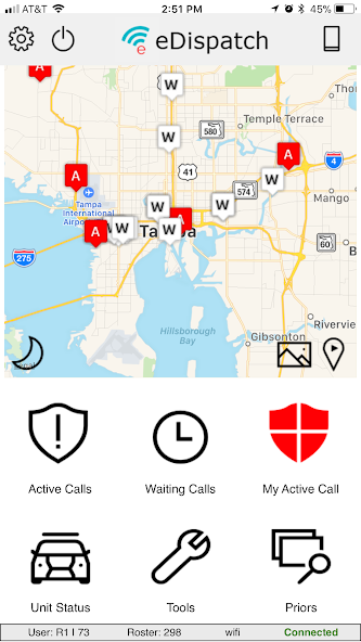
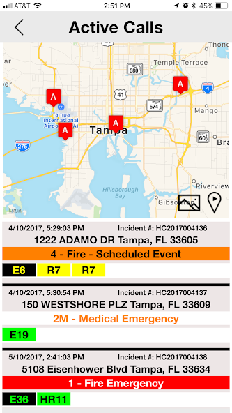
Stay informed of ongoing incidents in real time
El personal de respuesta a emergencias necesita acceso en tiempo real a información situacional crítica para responder de manera efectiva a los incidentes de la manera más rápida y segura posible. Para garantizar que su ley, incendios/EMS y los respondedores de ambulancia estén debidamente equipados con la información correcta en el momento adecuado para tomar decisiones informadas y entregar resultados de incidentes más rápidos y seguros, necesita una solución de despacho de computadora (CAD) de alto rendimiento fácil de usar, de alto rendimiento.
Improve call response times
Su ley, incendios/EMS y los respondedores de ambulancia pueden responder a los incidentes más rápido y tener un acceso rápido y fácil a la información crítica para ayudar a proteger mejor a sus ciudadanos y a sí mismos.
You'll maximize response performance and safety, and ensure your responders are better able to respond.
Your agency can:
• Simplify and accelerate response to emergencies and time-critical situations.
• Facilitate responder real-time access to critical information.
• Reduce responder dependency on dispatch by allowing field personnel to perform status changes and obtain incident information.
• Decrease radio traffic from the dispatch center by using silent dispatch
• Use visual representation of all units to enhance the strategic awareness and placement of resources.
Respond quickly
• Improve response times by receiving adjusted routing recommendations from dispatch with
turn-by-turn text directions based on factors such as street closures and construction.
• View routing information and nearby units on map screens.
• Initiate incidents from the field.
• Assign additional units as backups on calls.
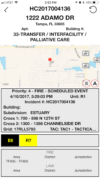
Quickly get critical information
• Vea fácilmente los botones de flag de precaución que proporcionan información como notas de precaución, información de contacto de emergencia, instrucciones de enfoque y requisitos especiales de equipos.
• Quickly access diagrams of major facilities that show ingress, egress, and navigation information, as well as hazmat material locations.
• Send and receive messages with the communications center and other field units.
• Scan driver's licenses and photographs.
Stay informed of ongoing incidents in real time
• Easily update and access incident information, unit states, and situation notes in real time.
• Acelere el acceso a la información con opciones de entrada como un teclado con soporte de una sola mano, teclas de función programables, soporte de pantalla táctil y pantallas de teclado de botones grandes.
** EnRoute Mobile is NOT affiliated with any government agency or entity.
**Information provided within the application comes from a direct connection to the computer aided dispatch application.
**Governmental information provided within the application may be associated with NCIC/CJIS data. Links to information regarding NCIC/CJIS/DOJ/FBI below.
(https://www.fbi.gov/services/cjis)
(https://www.justice.gov/tribal/national-crime-information-systems)
(https://www.ojp.gov/ncjrs/virtual-library/abstracts/national-crime-information-center-ncic-investigative-tool-guide-use)
**Agency information that may be included in the application includes:
Real-Time information regarding emergency calls including location details, nature of incident, and priority level.
** en ruta móvil permite a los respondedores ver mapas que contienen capas de información como calles, límites de la ciudad, zonas, cuadrículas e hidrantes y enrutamiento.
** EnRoute Mobile also facilitates communication between dispatchers and field units view messaging and chat.
 Descargar APK(177.17MB)